How to Use: Dji Matrice Drone M30T User Manual | Specs & Features
Content
Introduction
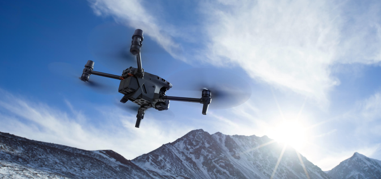
The DJI Matrice M30T is a powerful and portable commercial drone designed for demanding applications such as public safety, inspection, and mapping. With a 41-minute maximum flight time, 15 m/s wind resistance, and a service ceiling of 7000 m, the M30T delivers unparalleled performance. Its integrated multi-sensor payload includes a 48MP zoom camera, 12MP wide camera, thermal camera, and laser rangefinder, enabling comprehensive data capture. The DJI Matrice M30T is priced at $9,999, making it an invaluable tool for professionals requiring advanced aerial intelligence.
Vision System and Infrared Sensing System
The main components of the vision system (cameras with stereo vision sensors) are located on the front, rear, left, right, top and bottom of the aircraft. The infrared sensing system has two infrared sensors on each side of the aircraft (front, rear, left, right, top, and bottom).
The vision system constantly scans for obstacles and uses image data to calculate the aircraft position, and the infrared sensing system uses infrared sensors to detect obstacles and determine the flight altitude. Both systems work together to position the aircraft and sense obstacles during flight.
WARNING: To ensure a safe and steady flight, DO NOT block the vision and infrared sensors.
Detection Range
Detection Range of the Vision System
The detection range of the vision system is depicted below. Note that aircraft cannot sense obstacles that are out of the detection range. Fly with caution.
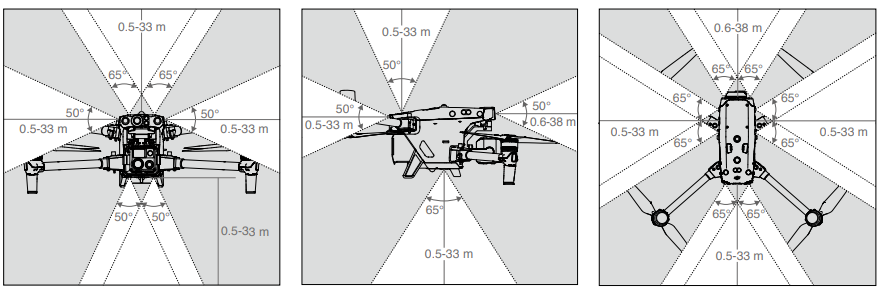
WARNING: The gray area is the blind spot of the vision system, where the aircraft cannot detect objects. Fly with caution.
TIP: Users can set the braking and warning distances in DJI Pilot 2. The aircraft brakes automatically when approaching the braking distance. When the aircraft is in the warning distance, DJI Pilot 2 will display an orange alert in obstacle information. When the aircraft is close to the braking distance, a red alert will appear in obstacle information.
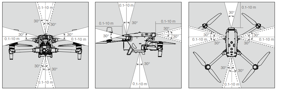
Detection Range of the Infrared Sensing System
The detection range of the infrared sensors is 0.1 to 10 m (0.33 to 33 ft). Be aware of the blind spot (marked grey) of the infrared sensing system. The Aircraft cannot detect and avoid obstacles that are out of the detection range.
Calibrating the Vision System
The vision systems installed on the aircraft is factory calibrated. If the aircraft experiences a collision or a significant change in the operating temperature, calibration may be required. Dul Pilot 2 will display a prompt when calibration is required. Follow these steps to calibrate the vision system when prompted:
- Power on the aircraft.
- Connect the assistant port of the aircraft to the computer.
- Launch DJI Assistant 2 (Enterprise Series) and log in using a DJl account.
- Select the M30 Series, then click the calibration button.
- Position the aircraft with the vision system facing the dotted pattern displayed on the computer screen, and follow the on-screen instructions to calibrate the vision sensors on each side.
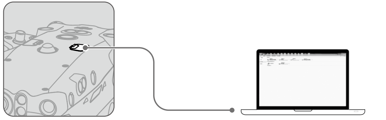
DO NOT power off the aircraft or unplug the cable after calibration. Wait for the data calculation to complete.
Vision Positioning
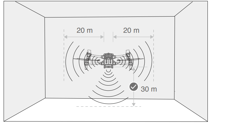
The vision system enables the aircraft to fly indoors or in environments where GNSS is not available. When the GNSS signal is available, the vision system provides information that improves aircraft positioning accuracy. The vision system works well when flying within 30 m (98.43 ft) above the ground and 20 m (65.62 ft) horizontally from any object to its side, provided that the object's surface has clear patterns or texture and the lighting is adequate. When the vision system is not working, the flight mode will switch to Attitude Mode.
If the vision system is disabled or blocked by other objects, the aircraft will not be able to hover indoors at a low altitude, and Landing Protection will not work. Control the landing speed as high-speed landing may damage the aircraft.
Obstacle Sensing
Obstacle sensing works best when the lighting is adequate and the obstacle is clearly textured. It does not work well with obstacles that are less dense such as twigs on a tree. The aircraft must fly at a speed below 17 m/s with a maximum tilt angel of 25° to ensure a sufficient braking distance. Aircraft cannot sense obstacles that are out of the detection range.
Infrared Sensing System
The infrared sensing system can only be used to sense large or highly reflective obstacles and rough surfaces. Aircraft cannot sense obstacles that are out of the detection range. The downward infrared sensing system is used for positioning and assisting with altitude calculations during takeoff and landing, while the infrared sensing system on the other five sides is for obstacle sensing.
Warnings
The measurement accuracy of the vision system is easily affected by the light intensity and the surface texture of the object. The infrared sensing system can only be used to sense large or highly reflective obstacles and rough surfaces. The vision system may NOT function properly in the following situations:
- Flying over monochrome surfaces (e.g., pure black, white, red, or green) or those without clear texture.
- Flying over surfaces with strong reflected light or images.
- Flying over water, ice, or transparent surfaces.
- Flying over moving surfaces or objects (e.g., moving crowds, or swaying reeds, shrubs, or grass).
- Flying in an area where lighting changes frequently or drastically or with direct exposure to strong light.
- Flying over extremely dark (< 15 lux) or extremely bright (> 10,000 lux) surfaces.
- Flying at high speeds below 2 m above the ground (e.g., faster than 14 m/s at a 2m height or 5 m/s at a 1m height).
- Small obstacles (e.g., iron wires, cables, tree branches, or leaves).
- The lens is dirty (e.g., from raindrops or fingerprints).
- In low-visibility environments (e.g., heavy fog or snow).
The infrared sensing systems may NOT detect the distance accurately in the following situations:
- Flying over surfaces that can absorb sound waves (e.g., asphalt road surfaces).
- A large area of strong reflectors situated at a distance of more than 15 m (e.g., multiple traffic signs placed side by side).
- Small obstacles (e.g., iron wires, cables, tree branches, or leaves).
- Mirrors or transparent objects (e.g., water or glass).
- In low-visibility environments (e.g., heavy fog or snow).
- Keep the vision sensors clean at all times. Any dirt or stain may affect their function.
- The vision system relies on surface patterns or texture to process image data and obtain position information. Make sure the surrounding environment has sufficient lighting and clearly textured ground.
- The vision system cannot function properly in dark environments and over surfaces without clear patterns or texture such as water and ice.
Specifications
| Category | Specifications |
|---|---|
| Aircraft | |
| Dimensions (unfolded, excl. propellers) | 470×585×215 mm (L×W×H) |
| Dimensions (folded) | 365×215×195 mm (L×W×H) |
| Diagonal Wheelbase | 668 mm |
| Weight (incl. two batteries) | 3770 ± 10 g |
| Max Takeoff Weight | 3998 g |
| Operating Frequency | 2.4000-2.4835 GHz, 5.725-5.850 GHz |
| Transmitter Power (EIRP) | 2.4 GHz: <33 dBm (FCC); <20 dBm (CE/SRRC/MIC) |
| Hovering Accuracy (windless or breezy) | Vertical: ±0.1 m (Vision System enabled) |
| RTK Positioning Accuracy (fixed RTK enabled) | 1 cm+1 ppm (horizontal), 1.5 cm+1 ppm (vertical) |
| Max Angular Velocity | Pitch: 150°/s; Yaw: 100°/s |
| Max Tilt Angle | 35° (N-mode and Forward Vision System enabled: 25°) |
| Max Ascent/Descent Speed | 6 m/s; 5 m/s |
| Max Tilt Descent Speed | 7 m/s |
| Max Horizontal Speed | 23 m/s |
| Max Wind Resistance | 15 m/s |
| Max Hover Time | 36 min |
| Max Flight Time | 41 min |
| Ingress Protection Rating | IP55 |
| GNSS | GPS+Galileo+BeiDou+GLONASS |
| Operating Temperature | -20° to 50° C (-4° to 122° F) |
| Gimbal | |
| Angular Vibration Range | ±0.01° |
| Controllable Range | Pan: ±90°; Tilt: -120° to +45° |
| Mechanical Range | Pan: ±105°; Tilt: -135° to +60°; Roll: ±45° |
| Zoom Camera | |
| Sensor | 1/2'' CMOS, Effective pixels: 48M |
| Lens | Focal length: 21-75 mm (equivalent: 113-405 mm), Aperture: f/2.8-f/4.2, Focus: 5 m to ∞ |
| ISO Range | 100-25600 |
| Max Photo Size | 8000×6000 |
| Wide Camera | |
| Sensor | 1/2'' CMOS, Effective pixels: 12M |
| Lens | DFOV: 84°, Focal length: 4.5 mm (equivalent: 24 mm), Aperture: f/2.8, Focus: 1 m to ∞ |
| Max Photo Size | 4000×3000 |
| Thermal Camera | |
| Sensor | Uncooled VOx Microbolometer |
| Infrared Temperature Measurement Accuracy | ±2°C or ±2% (using the larger value) |
| Max Photo Size | Infrared Image Super-resolution Mode: 1280×1024 Normal Mode: 640×512 |
| Pixel Pitch | 12 μm |
| FPV Camera | |
| Resolution | 1920×1080 |
| DFOV | 161° |
| Frame Rate | 30 fps |
| Laser Module | |
| Wavelength | 905 nm |
| Max Laser Power | 3.5 mW |
| Measuring Range | 3-1,200 m (0.5×12 m vertical surface with 20% reflectivity) |
| Vision Systems | |
| Obstacle Sensing Range | Forward: 0.6-38 m |
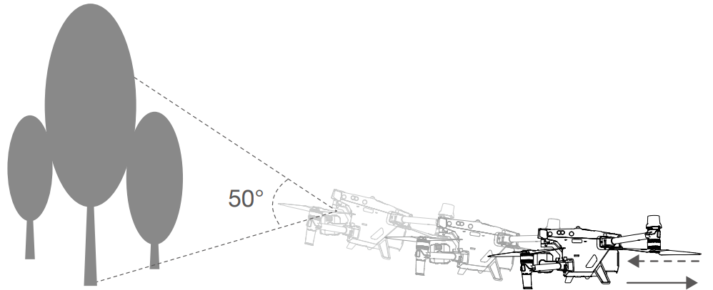
| FOV | 65° (H), 50° (V) |
| Operating Environment | Surfaces with clear patterns and adequate lighting (> 15 lux) |
| Infrared Sensing Systems | |
| Obstacle Sensing Range | 0.1-10 m |
| FOV | 30° |
| TB30 Intelligent Flight Battery | |
| Capacity | 5880 mAh |
| Voltage | 26.1 V |
| Battery Type | Li-ion 6S |
| Energy | 131.6 Wh |
| Net Weight | Approx. 685 g |
| Operating Temperature | -20° to 50° C (-4° to 122° F) |
| Remote Controller | |
| Screen | 7.02 inch LCD touchscreen |
| Internal Battery | 6500 mAh @ 7.2 V |
| External Battery | WB37 Intelligent Battery: 4920 mAh, 7.6 V |
| Operating Time | Internal Battery: Approx. 3 hours 18 min |
| O3 Enterprise | |
| Operating Frequency | 2.4000-2.4835 GHz, 5.725-5.850 GHz |
| Max Transmission Distance | 15 km (FCC); 8 km (CE/SRRC/MIC) |
| Wi-Fi | |
| Protocol | Wi-Fi 6 |
| Bluetooth | |
| Protocol | Bluetooth 5.1 |
| Operating Frequency | 2.4000-2.4835 GHz |
| Intelligent Flight Battery | |
| Model | CSX320-550 |
| Net Weight | 3.95 kg |
| Compatible Battery Type | TB30 Intelligent Flight Battery WB37 Intelligent Battery |
| Input | 100-240 VAC, 50/60 Hz |
| Output Power | 525 W |
- 5.8 and 5.1 GHz frequencies are prohibited in some countries. In some countries, the 5.1GHz frequency is only allowed for use indoors.
- The maximum flight time and the hover time were tested in a lab environment and is for reference only. (3) This protection rating is not permanent and may reduce over time after long-term use.
- The infrared temperature measurement accuracy was tested in a lab environment and is for reference only.
- The maximum operating time was tested in a lab environment and is for reference only.
- The charging time was tested in a lab environment at room temperature. The value provided should be used for reference only.
Aircraft
The M30 Series aircraft mainly consists of the flight control system, communication system, vision system, image processing system, propulsion system, and power and battery system. This chapter provides a detailed introduction to the aircraft components and functions.
Activating the Aircraft
After the aircraft is linked to the remote controller (make sure the remote controller is connected to the internet), the DJI Pilot 2 app will display the prompt: "There's a DJI device not activated". Follow the on-screen instructions to activate the aircraft. Contact DJI Support if the activation fails. Refer to the Link the Remote Controller section for details.
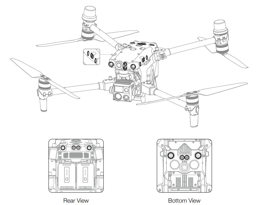
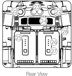
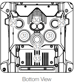
Aircraft Overview
- FPV Camera
- Forward Infrared Sensing System
- Forward Vision System
- Left and Right Vision Systems
- Left and Right Infrared Sensing Systems
- microSD Card Slot
- Upward Vision System
- Upward Infrared Sensing System
- Power Button/Indicator
- PSDK Port
- Upward Beacon
- Assistant Port
- Frame Arm Folding Buttons
- Frame Arms
- Motors
- Propellers
- Aircraft Rear Indicators
- GNSS Antennas
- Video Transmission Antennas
- Aircraft Front Indicators
Gimbal and Camera [1]
The M30 and M30T are equipped with different cameras. Refer to the actual product purchased.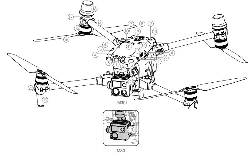
- Backward Vision System
- Backward Infrared Sensing System
- Air Vent
- TB30 Intelligent Flight Battery
- Battery Level LEDs
- Battery Level Button
Battery Release Toggle
- Downward Vision System
- Downward Infrared Sensing System
- Bottom Auxiliary Light
- Downward Beacon
Dongle Compartment
DO NOT disassemble the product without the assistance of a DJI authorized dealer (except for components allowed to be disassembled by users in this guide), otherwise it will not be covered under warranty.
Description
The DJI Matrice 30T is built with durability in mind, featuring a rugged design that can withstand harsh weather conditions. It includes a tri-antenna system for stable signal transmission and supports real-time video transmission over long distances. The drone is equipped with advanced obstacle avoidance sensors and a redundant system design to ensure safe and reliable operation.
The M30T also comes with DJI's RC Plus remote controller, which offers a high-resolution display and long battery life. This combination makes the M30T an ideal solution for extended field operations.
FPV Camera
The M30 Series aircraft is equipped with a starlight FPV camera, which can optimize images in poor lighting conditions at night. It helps the pilot to have better visibility of the flight environment and fly safely.
Propellers
Using the Propellers
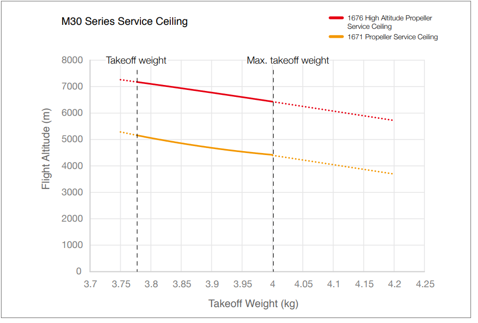
The M30 Series aircraft supports both the 1671 Propeller and the 1676 High Altitude Propeller (excluded). Refer to the diagram below to choose the appropriate propellers according to the aircraft takeoff weight and the expected maximum flight altitude.
The service ceiling is the theoretical maximum altitude that the aircraft can fly at normally, on the condition that the wind speed does not exceed 15 m/s when flying and 12 m/s when taking off or landing. The aircraft braking and acceleration capabilities will be reduced when flying near the service ceiling. Use the 1676 High Altitude Propeller when flying at altitudes higher than 3,000 m (9,842.5 ft) above sea level.
- Using high altitude propellers for extended periods may reduce motor life.
- Only use official DJI propellers. DO NOT mix propeller types.
- Propellers are consumable components. Purchase additional propellers if necessary.
- Make sure that the propellers and motors are installed securely before each flight.
- Make sure that all propellers are in good condition before each flight. DO NOT use aged, chipped, or broken propellers.
- To avoid injury, stay away from rotating propellers or motors.
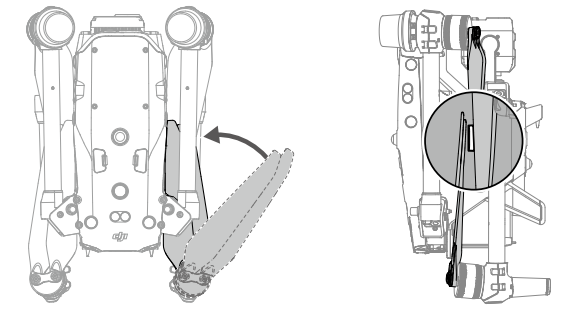
Storing the Propellers
Follow the diagram to fold and store the propellers.
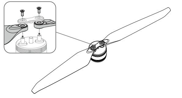
Replacing the Propeller Blades
Use the H2.0 hex key to replace the propellers.
It is recommended to replace the propellers only in an emergency situation during operations. After the flight is over, contact DJI Support or an authorized dealer for propeller check and maintenance as soon as possible.
WARNING: The propeller blades are sharp. Handle with care.
Setup Guide
To operate the DJI Matrice 30T, follow these steps:
- Assembly: Attach the propellers and any additional payloads according to the user manual.
- Configuration: Update the drone's firmware and configure settings through the DJI Pilot 2 app.
- Pairing: Pair the drone with the RC Plus remote controller via the app.
- Calibration: Calibrate the drone's compass and IMU before each flight.
- Pre-Flight Check: Conduct a thorough pre-flight check to ensure all systems are functioning correctly.
DJI Matrice 30T Flight Safety
Make sure to have training and practice before operating any actual flight. Practice with the simulator in DUl Assistant 2 or fly under the guidance of experienced professionals. Pick a suitable area to fly in according to the following flight requirements and restrictions. Fly the aircraft below 120 m (400 ft). Any flight altitude higher than that may violate local laws and regulations. Make sure you understand and comply with the local laws and regulations before flying. Read the Disclaimer and Safety Guidelines carefully to understand all safety precautions before flying.
Flight Environment Requirements
- DO NOT fly the aircraft in severe weather conditions. These include strong winds exceeding speeds of 15 m/s, snow, rain, fog, hail, lightning, tornadoes, hurricanes, and other weather with low visibility.
- Place the aircraft on open and unobstructed flat ground to take off. Make sure the aircraft is at a safe distance from any surrounding obstacles, buildings, crowds, or trees. Fly the aircraft within the visual line of sight (VLOS) to ensure flight safety.
- If light conditions surrounding the aircraft are poor, the navigation information on DJI Pilot 2 will show that the vision system or infrared sensing system is not functioning. This means the vision system and the infrared sensing system may not be working properly and the aircraft is unable to sense obstacles. Observe the surrounding environment at all times through the live FPV camera view and maintain control of the aircraft to ensure flight safety.
- Make sure the beacons and the auxiliary lights are enabled at night for flight safety.
- DO NOT take off from a moving vehicle.
- To avoid affecting the motor service life, DO NOT take off or land the aircraft on sandy or dusty areas.
Wireless Communications Requirements
- Make sure that the antennas on the front arms and the bottom of the aircraft body are not damaged or loose.
- Fly in wide open areas. Tall buildings, steel structures, mountains, rocks, or tall trees may affect the accuracy of the GNSS and block the video transmission signal.
- To avoid interference with the remote controller from other wireless equipment, make sure to power off nearby Wi-Fi and Bluetooth devices when controlling the aircraft remotely.
- Be extremely alert when flying near areas with magnetic or radio interference. Pay close attention to the video transmission quality and signal strength on DJI Pilot 2. Sources of electromagnetic interference include but are not limited to: high voltage lines, large scale power transmission stations or mobile base stations, and broadcasting towers. The aircraft may behave abnormally or lose control when flying in areas with too much interference. Return to the Home Point and land the aircraft if prompted to do so in DJI Pilot 2.
Troubleshooting
- Signal Loss: Check antenna alignment and ensure there are no obstructions between the drone and remote controller.
- Camera Issues: Restart the drone and check for firmware updates. Ensure proper camera calibration.
- Propeller Damage: Inspect propellers for damage and replace if necessary. Always handle propellers with care.
Always refer to the user manual for detailed troubleshooting instructions and follow safety guidelines to avoid injury or damage.
Pros & Cons
Pros
- Durable Design: Built to withstand harsh weather conditions.
- Advanced Cameras: High-quality imaging capabilities.
- Long Flight Time: Up to 41 minutes of flight time.
- Stable Transmission: Reliable signal transmission over long distances.
Cons
- High Cost: Estimated price range of $10,000 to $15,000.
- Complex Setup: Requires careful assembly and configuration.
- Weight and Size: Bulky and heavy, requiring careful handling.
Customer Reviews
Customers praise the Matrice 30T for its robust build quality and exceptional imaging capabilities. However, some users have noted that the setup process can be complex and time-consuming. Common complaints include the high cost and the need for regular maintenance to ensure optimal performance.
Faqs
What is the estimated price range of the DJI Matrice 30T?
What are the key features of the DJI Matrice 30T?
How do I assemble the DJI Matrice 30T?
What is the purpose of the tri-antenna system on the DJI Matrice 30T?
Can I use the DJI Matrice 30T in harsh weather conditions?
How do I troubleshoot signal loss issues with the DJI Matrice 30T?
What is the range of the DJI Matrice 30T?
Does the DJI Matrice 30T come with a remote controller?
How do I update the firmware of the DJI Matrice 30T?
Can I customize the payloads on the DJI Matrice 30T?
Leave a Comment