
Garmin 10X2/12X2 Marine Chartplotter GPSMAP User Manual
Content
Garmin GPSMAP 10x2/12x2 Marine Chartplotter GPS: Complete Product Manual
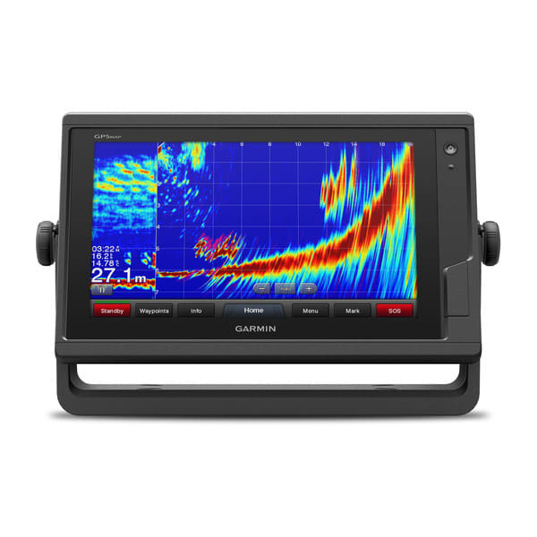
The Garmin GPSMAP 10x2/12x2 marine chartplotter GPS is built for boaters who want a bright, reliable navigation display with advanced charting, networking, and sonar integration. Available in 10.1-inch and 12.1-inch classes, this series is designed for serious anglers, cruisers, offshore captains, and multi-display helm setups that need dependable marine GPS performance in a rugged form factor.
The main appeal of the Garmin GPSMAP 10x2/12x2 Marine Chartplotter GPSMAP series is its balance of screen size, clarity, and expansion potential. The 10x2 model is ideal for smaller helms that still need a large, readable interface, while the 12x2 version offers more viewing area for split-screen navigation, sonar, and engine data. These units support modern marine network integration, chart plotting, waypoint management, and compatibility with Garmin marine accessories, making them a flexible choice for recreational and professional use.
Typical pricing varies by configuration, chart bundle, and transducer inclusion, but the series generally falls in the mid-to-premium range for marine multifunction displays. Bare units often start around the low-to-mid four figures, while bundled packages with charts and transducers can cost significantly more. Availability is strongest through marine electronics retailers, online boating stores, and authorized Garmin dealers. For buyers searching for a dependable chartplotter with strong ecosystem support, the Garmin GPSMAP 10x2/12x2 Marine Chartplotter GPS remains a highly practical option.
Specifications for Garmin GPSMAP 10x2/12x2 Marine Chartplotter GPSMAP
- Display size: 10.1-inch diagonal on 10x2 models; 12.1-inch diagonal on 12x2 models
- Display resolution: WSVGA, 1024 x 600 pixels on 10x2 units
- Dimensions: 31.8 x 18.5 x 6.9 cm for 10x2; 35.8 x 22.6 x 6.9 cm for 12x2
- Weight: 1.85 kg for 10x2; 2.34 kg for 12x2
- Water rating: IPX7 for marine splash and rain protection
- Operating temperature: -15°C to 50°C
- Memory card support: 2 SD card slots, up to 32 GB maximum
- Typical current draw at 12 Vdc: 1.9 A for 10x2; 2.2 A for 12x2
- Maximum current draw at 12 Vdc: 2.7 A for 10x2; 2.9 A for 12x2
- Maximum power usage at 10 Vdc: 32.4 W for 10x2; 34.8 W for 12x2
- Materials: polycarbonate plastic and die-cast aluminum
- Wireless frequency: 2.4 GHz connectivity support
- Compass-safe distance: 65 cm for magnetic interference awareness
Compared with smaller entry-level chartplotters, this series delivers larger screens and stronger networking flexibility. Compared with higher-end premium units, it offers a more accessible price while still providing serious marine navigation capability and a robust installation footprint.
Detailed Overview of the Garmin GPSMAP 10x2/12x2 Marine Chartplotter GPS
The Garmin GPSMAP 10x2/12x2 Marine Chartplotter GPS functions as a central navigation and information hub on the boat. It displays charts, routes, waypoints, sonar views, and system data in one place, helping captains make faster decisions at the helm. The interface is designed for marine use, with a clear layout that works well in bright daylight and rough-water conditions.
In real-world use, these chartplotters are ideal for coastal cruising, offshore fishing, harbor navigation, and long-distance route planning. Users can build routes, mark fishing spots, monitor depth-related information through compatible sonar systems, and connect the display to a wider Garmin marine network. The build quality is strong, combining polycarbonate and die-cast aluminum for a durable feel that suits demanding marine environments.
Owners typically appreciate the large display area and the ability to split the screen for multiple data sources. The 12x2 model is especially useful for users who want to keep charts, sonar, and engine information visible at the same time. The Garmin GPSMAP 10x2/12x2 Marine Chartplotter GPS is best understood as a flexible helm display rather than a simple GPS screen.
Setup Guide: How to Install and Configure Garmin GPSMAP 10x2/12x2 Marine Chartplotter GPSMAP
- Choose a mounting location with clear visibility, proper ventilation, and safe access to power and network cables.
- Mount the unit using the recommended flush or bail mounting method for your helm layout.
- Connect the power cable to a protected 12 Vdc marine power source with the correct fuse protection.
- If using charts, insert supported SD cards into the memory card slots before powering on.
- Connect sonar, radar, or network accessories only with compatible Garmin marine cables and approved hardware.
- Power on the display and follow the setup wizard to select language, region, time, and chart preferences.
- Pair wireless accessories if needed, then test GPS lock, chart loading, and screen brightness settings.
- Run a dockside systems check before heading out to confirm data sources and alarms are functioning correctly.
Safety matters during installation. Disconnect power before wiring, avoid routing cables near heat or sharp edges, and verify that all connections are dry and secure. If the display does not power on, check fuse integrity, voltage supply, and cable seating first. For unstable networking, confirm that only marine-rated Garmin network cables are used and that all connected devices are powered correctly.
Troubleshooting Garmin GPSMAP 10x2/12x2 Marine Chartplotter GPSMAP Problems
- Unit will not power on: Check the fuse, verify battery voltage, inspect the power connector, and confirm the helm switch is supplying current.
- Screen is dim or unreadable: Increase brightness, disable night mode, and inspect the power supply for voltage drop.
- No GPS signal: Move to open sky, wait for initial satellite acquisition, and make sure the antenna path is unobstructed.
- Charts do not appear: Confirm the SD card is inserted properly and that the chart format is supported.
- Network devices are missing: Recheck Garmin Marine Network cabling, restart devices, and verify that each device has power.
- Touch or control response is delayed: Restart the unit and make sure the display is clean and dry.
If problems continue, perform a factory reset only after backing up routes and waypoints. Preventive care includes keeping ports sealed, using marine-grade wiring, updating system software when available, and avoiding prolonged exposure to extreme heat. Warranty support and technical assistance are available through Garmin’s official marine support channels, authorized dealers, and registered service partners. Customers should have the product serial number, purchase details, and a clear description of the issue ready before contacting support.
Pros and Cons of Garmin GPSMAP 10x2/12x2 Marine Chartplotter GPSMAP
Pros
- Large, easy-to-read marine displays for navigation and split-screen use
- Rugged construction with IPX7 water resistance and durable materials
- Strong Garmin ecosystem support for sonar, radar, and networking
- Flexible installation options for different helm sizes
- Good value for boaters who want premium functionality without moving to the highest-priced class
Cons
- Premium bundles can become expensive once charts and transducers are added
- Larger footprint may be tight on compact consoles
- Setup can feel complex for first-time marine electronics users
- Best performance depends on compatible Garmin accessories and proper installation
For buyers comparing alternatives, the 10x2 is often the better choice for moderate helm space, while the 12x2 is stronger for users who want a bigger interface and more comfortable split-screen operation. Overall, the Garmin GPSMAP 10x2/12x2 Marine Chartplotter GPS offers solid value for serious boaters who need a reliable long-term navigation platform.
Customer Reviews and User Feedback
Average user sentiment for the Garmin GPSMAP 10x2/12x2 Marine Chartplotter GPS is typically positive, with many owners rating it around 4 to 5 stars for screen clarity, navigation accuracy, and system expandability. Boaters often praise the bright display, responsive interface, and strong integration with other Garmin marine products.
Common complaints usually focus on price, installation complexity, and the cost of adding charts or sonar accessories. One recurring testimonial style comment is: “The screen is easy to read in sunlight and makes split-screen navigation much simpler at the helm.” Another frequent remark is: “It works great once installed, but plan carefully if you want a full networked setup.”
Most buyers recommend this series for serious recreational boating, fishing, and offshore use rather than casual weekend trips. If you want a dependable, scalable chartplotter with a strong feature set, the Garmin GPSMAP 10x2/12x2 Marine Chartplotter GPS is a smart purchase.
Faqs
How do I set up garmin 10X2/12X2 Marine Chartplotter GPSMAP for the first time on my boat?
Why is my garmin 10X2/12X2 Marine Chartplotter GPSMAP not getting a GPS signal, and how can I fix it?
Which chart formats and marine maps work best with garmin 10X2/12X2 Marine Chartplotter GPSMAP?
How do I connect garmin 10X2/12X2 Marine Chartplotter GPSMAP to sonar, radar, and autopilot systems?
What should I do if garmin 10X2/12X2 Marine Chartplotter GPSMAP keeps freezing, rebooting, or running slowly?
How can I optimize chart visibility and touchscreen responsiveness on garmin 10X2/12X2 Marine Chartplotter GPSMAP in bright sunlight?
What maintenance and cleaning routine helps garmin 10X2/12X2 Marine Chartplotter GPSMAP last longer in saltwater conditions?
Is garmin 10X2/12X2 Marine Chartplotter GPSMAP compatible with NMEA 2000 and other onboard electronics?
More garmin manuals
Leave a Comment